History
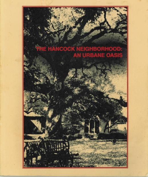
The Hancock Neighborhood: An Urbane Oasis
Richard A. Thompson, Editor, 1999
This book is dedicated to the residents of our wondrous neighborhood both present and past.
© Copyright 1999, 2011 Hancock Neighborhood Association. All rights reserved.
"Inshallah" Cover Art by Daniel Garza
Foreword
Richard A. Thompson, Editor
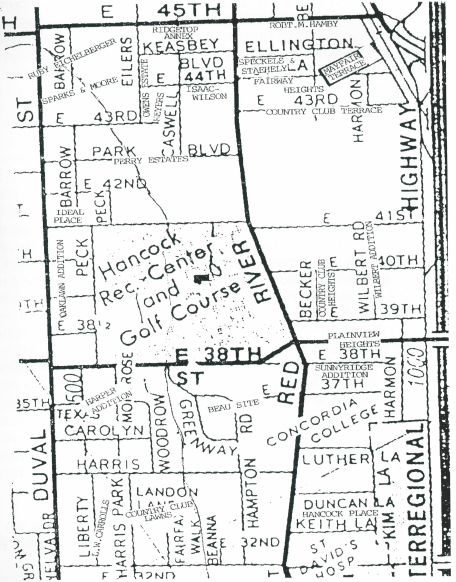
The celebration of the Centennial of the Hancock Golf Course in 1999 is a fitting occasion for producing a history of the area through the sponsorship of the Hancock Neighborhood Association (H. N. A.). The purpose is to provide a record for the future and to foster community building in the present. The title was chosen by the History Committee to reflect the experience of those who live in the area bounded by 32nd Street to the south, 45th street to the north, Duval Street to the west and Interstate 35 (I-35) to the east. This near-north side of Austin is urbane because of its proximity to Austin's downtown, to the State Capitol, and to the University of Texas, with residents both contributing to and benefiting from the social and cultural resources of that environment. Yet in the midst of the region's explosive growth, there is an ambiance and tranquility in the vicinity, which has been a blessing to residents over the decades.
This theme is developed throughout the Overview of the Hancock's area past, as well as through the four topical essays. Besides my taking the lead in writing the Overview, others have added much to the section. Geologist Charles Woodruff Jr. provided important information, with Jon Kalb, drawing the geological map of the area. Else Plumb Kidd prepared the portion on The Oak Lawn Addition & Ideal Place, and David Orr on the 1920-1945 era. Barbara A. Manz made particular input about Concordia University.
The topical essays have been written by others on the History Committee. The one on architecture is by Professor Emeritus of Architecture at the University of Texas Blake Alexander. Neighborhood residents wrote the other essays including the one on the Hancock Golf Course by John Ramzy, and on the Hancock Shopping Photo of Richard A. Thompson Center by Jalaane Levi-Garza and Louis Pauls. John Brodie is author of the essay on Beau—Site: A Case Study, in which the recounting of properly owners, deed restrictions/conditions, and changing of street names within one neighborhood affords a crossrsectional view across the decades. John has also worked with me to edit the entire text and has performed the yoeman job of word-processing the material.
We are indebted to the Austin History Center for the use of maps of the 1840s and of the early 20th century Hancock neighborhood maps. We are grateful to the Hancock Recreation Center for use of photos and drawings pertaining to the golf course. Daniel Garza photographed and contributed images of area homes and buildings.
It is through this cooperative effort, plus the financial support of those listed as contributors that this volume has been made possible. May those living in this community now and in the future better appreciate through these pages how the Hancock Neighborhood is indeed an urbane oasis and how it is worthy of all preservation efforts, historical and otherwise.
Introduction - The Namesake
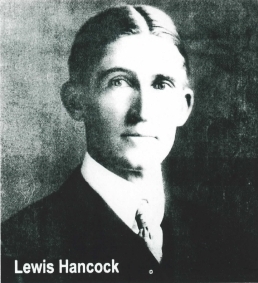
The namesake of the Hancock Neighborhood in Austin, Texas was a pioneer of early Texas. He was Lewis Hancock, the son of George Hancock, Battle of San Jacinto veteran, and the co-owner from the 1830s of the Trading Post at Sixth and Congress, where the Scarbrough Building stands.
George Hancock's business partner, Frances Dietrich, built a one-story structure at what is today 3401 Red River. For decades this property was on the outer edge of Austin, along a road leading north to Georgetown from Austin. In 1850 Dietrich added a two-story home to it, calling it Sunnyridge. Indians killed him a year later. His widow married Joseph Whipple, who sold it to Lewis Hancock in 1900. Hancock resided in that home until his death in 1920. His daughter Mildred Hancock continued living there until her death. The house was sold and bulldozed in 1967, making way for the Century Square apartments that currently stand on the site. The Hancock family represents a 130-year transition in the life of Austin from the days of the Republic of Texas to the modern era.
Geological Origins
Charles Woodruff, Jr.
A recounting of the origins of the area would be incomplete without recognizing how the geological substructure has determined land use. Three major geological events shaped the Austin area: the Cretaceous Seas, the formation of the Balcones Fault Zone, and subsequent erosion of the landscape by the Colorado River and its tributaries.
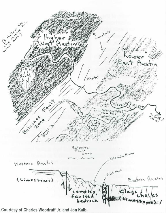
Marine deposits between 65 and 145 million years ago formed the limestone strata, which underlie Austin. At that time, a vast inland sea covered the interior of what is now North America. During the late stages of the Cretaceous epoch, volcanoes formed along a buried hinge (the subsided stumps of the Ouachita Mountains) that would later mark the edge of the Balcones Fault system. Pilot Knob, in southeast Austin, is the remains of one of these volcanoes.
Approximately 20 to 25 million years ago, rocks underlying what is now Central Texas were broken and displaced downward toward the Gulf of Mexico. This resulted in mountain building in Colorado and New Mexico to the west and sediment deposits along the Texas coast to the southeast. This belt of broken rock, which makes up the Balcones Fault Zone, extends from Del Rio, northeastward through San Antonio and Austin, and beyond. It has profound influences on today's landscapes and water resources. The limestone, uplifted to the west, has been sculpted into the Hill Country west of the fault line; to the east, softer chalks and claystones have been eroded to lower levels, forming the Blackland Prairies.
As described by geologist and former President of the University of Texas Peter T. Flawn, "the Balcones fault line is where the West really begins." The cotton economy of the Old South meets the cattle economy of the Old West at the Balcones Escarpment, where the Blackland Prairies abut the hardscrabble hills.
That immense crack in the earth's surface created the anomaly of older Cretaceous limestone hills in west Austin being higher than the younger Blackland Prairie at lower elevations in the east. Parallel fault lines are most evident east of the Mount Bonnell Fault. Both Shoal Creek and Waller Creek follow along the parallel faults. Joseph Jones in his Life on Waller Creek, A Palaver about History as Pure and Applied Education, notes how Waller Creek began as no more than a trickle along a stretch of Cretaceous limestone.
The whole Hancock area is underlain by this Austin Chalk, which is evident by the road-cut along 38th street, west of Red River, on the south end of the golf course. Waller Creek exposes the chalk bedrock in many places, as well as minor fault traces. The creek provides the north-south axis of the Hancock area; it is understandable how it defines so much of the land-use from the beginning of human habitation.
Native Americans
The Native Americans in this part of the state were the Tonkawa, according to W. W. Newcomb Jr., in his The Indians of Texas from Prehistoric to Modern Times. They were nomadic hunters, gatherers, and fishermen, for whom the bow and arrow were most important. They camped along streams and rivers and in burnt-out rock middens of the earlier Archaic cultures. From the 16th century, Indians roamed from as far west, as the uppermost Edwards Plateau on to the Coastal Plain, and as far east as the Brazos River bottoms. In 1839 Waller Creek was teeming with fish. With buffalo and deer abounding in its vicinity, game was plentiful and abundantly harvested by the Tonkawa. By 1850 game had diminished and the Tonkawa were confined to reservations, with a very small population numbering only in the hundreds.
Arrowheads of Native Americans have been found along Waller Creek, where it turns to the northeast towards the Elisabet Ney Museum - on an 80 acre tract deeded to Angelina D. Smith by Republic of Texas President Sam Houston on December 16, 1841. In the 1920s, George Dempsey, a recent owner of a portion of that property, collected artifacts from tribes of the vicinity. The Dempsey House still stands at 700 E. 44th St.
Since the days of Anglo settlement, the Cretaceous strata have been used for quarries and limestone production. Drill holes and blast marks can be identified along Waller Creek from the south of 38th Street and north to 41st Street. The Perry family converted such a quarry, located on the southeast corner of the former Perry Estate, into a sunken garden. The otherwise flat-laying land in the flood plain of Waller Creek was used mostly for dairy farming. But as later described, the principal land use of the Hancock area became residential, especially triggered by the founding of the Austin Country Club at the turn of the century. Subdivisions grew up around this geographical and social center of the community.
Early Anglo Settlement - to 1890
The earliest plat maps, besides showing the name of Angelina D. Smith, also include that of John Henry Lohmann who bought 40 acres from her in 1847. Here he established the first, and until 1861, the only dairy in Travis County. In 1910 the first significant housing development took place on this acreage, when W.T. Caswell purchased land for the purpose of subdividing.
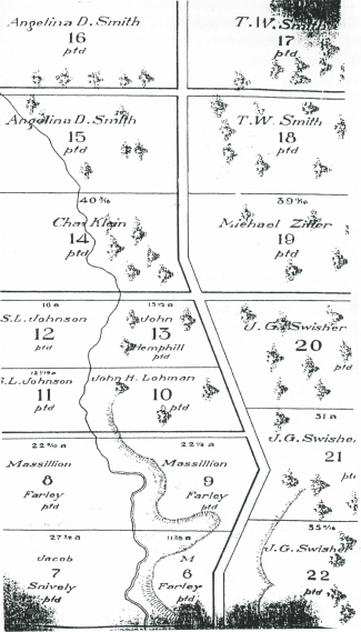
Joseph Lucksinger purchased another portion of the land of the Smith property in 1871. Here he built a two-room stone cabin and established one of the first slaughterhouses in Austin, furnishing meat to Austin and state institutions, according to Susan M. Ridgway in the May 1981 issue of Austin magazine.
Early beginnings are also represented by Ideal Place, the subdivision northwest of the Hancock Golf Course, from 41st to 44th Streets along the east side of Duval Street, extending to Waller Creek. Its history commenced on Christmas Day in 1846 when Charles Klein of Switzerland arrived with his family at the Port of Galveston, Texas. He registered his mark and brand in 1847 at the Travis county courthouse. In 1848, he was granted 40 acres by the State of Texas, being Outlot No. 14 in the Division C of a tract adjoining the City of Austin. On census records, he is listed as a stock-raiser and farmer. The property remained in the family until the 1890s, when it passed to others. By 1911 T. H. Barrow, an Austin realtor, and W. K. Ward of Ellis County, owned Outlot 14, and filed the plat for Ideal Place at the Travis County Courthouse.
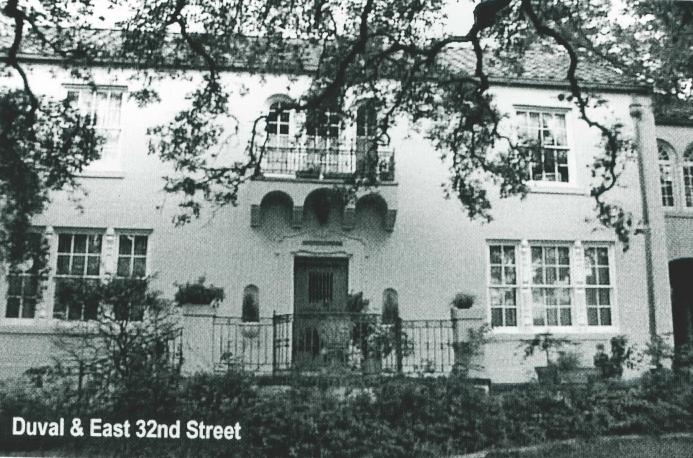
A notable individual living in the Hancock area during this period was Susanna Dickinson, who with her infant daughter Angelina, survived the carnage of the Alamo, as they were given leave by Santa Anna. According to Women in Early Texas, edited by Evelyn M. Carrington, Dickinson, with her husband, Joseph W. Henning, moved to the corner of Duval and 32nd streets in the 1870s. She lived until 1883. Henning, who had opened a furniture and cabinet shop at 205 east Pecan, continued to trade in real estate.
Turn of the Century Founders
Lewis Hancock is listed as the first to lead, in giving definition to the area at the turn of the century, by founding the Austin Country Club. In doing so, he provided a magnet, which attracted others like the Perry, Bailey and Fisher families.
Lewis was known also for having served as Austin's mayor, from 1895 to 1897 and builder of the Hancock Opera House, at 120 West Sixth, in 1896. It was during his travels in the United States and Scotland the he developed a keen interest in the game of golf. According to David Gunther's A Short History of Hancock Recreation Center, printed in the November, 1986 issue of FUTURELOOK, "Hancock gathered a group of like-minded enthusiasts at the Driskill Hotel in 1899 to draw up plans for the construction of a golf course in Austin." Gunther states that this course was the first in Texas, and only the second of its kind in the south. The original golf course had nine holes, located on a strip of land, which bordered Duval. The Ernst Farm, at 41st and Red River, was purchased in 1913 to created another nine holes. This land was adjacent to the Hamby farm to the north.
Once the property was purchased, developments began to build up around the course. Aldridge Place was the one Hancock took the most hand in developing. Peter Flagg Maxson, in his paper Aldridge Place, the 'Suburb Beautiful', writes that Hancock sought to create an extended country club suburb between the University and the golf club. Although this neighborhood between Guadalupe and Speedway, 30th and 34th Streets, is outside the Hancock neighborhood boundaries, it represents the same impetus to build in proximity to the golf course.
Another visible sign of the influence of the golf course on the surrounding areas is to be found in the name of Greenway, the street that led directly to the links, from the Beau Site neighborhood to the south. That acreage was purchased by James Robinson Bailey (1868-1941). his home 3504 Hampton Road, was constructed in in 1910. In written material supplied by the current owner, Becky Phillips, it is reported how he served as Professor of Chemistry at the University of Texas. During World War I, he and his associate Alcan Hirsch succeeded in "cracking" the German formula for Novocaine. Subsequently, he is said to have sent more students along the route to Ph.D. degrees than any other professor in the University.
It was another University of Texas professor, political scientist Dr. Lindsey M. Keasbey, who in 1907 purchased the Lucksinger property. According to the previously cited Susan M. Ridgway, Mr. Keasbey led in the building o their home. She ". . . would come out clasping in her arms one of the volumes of her beautiful 12-volume edition of the Arabian Nights and she and the builder would pore over the illustrations in this and make their plans." She gave the Moorish-style structure the Arabic name "Inshallah."
As the city of Austin grew northward, the Hancock area continued to change from earlier farm and dairy use to residential. Soon after the turn of the century, the largest additions to be platted were Beau Site, Oaklawn, Harpers, Ideal Place, and Plainview Heights. Lot sizes varied greatly.
Typical of the newly formed subdivisions was that of the Oaklawn Addition. The original patent to these Outlots 11 and 12 was held by Solomon L. Johnson. He purchased these from the state in 1846. Later it passed to the Richard H. Peck family and for many years was known as "Peck Place." Mr. Peck owned a general merchandise store at the present site of the Driskill Hotel.
On May 1, 1905, a plat was filed at the Travis County Courthouse by developers Carl Luetche and W. G. Sneed. It was bounded by East 41st Street on the north, East 38th Street on the south, Waller Creek on the the east and Groomes (now Duval) on the west. Three avenues ran east and were named Terrell, Ross, and Johnson. Peck Avenue ran north and south. Lots were 25' x 145' with alleyways. In 1906, the land was sold from Peck Avenue to Waller Creek to the Austin Country Club.
From the 1920s to 1945
The City of Austin had a population of 34, 876 in 1920 and the Hancock neighborhood was near the northeast corner of the city limits. East Avenue (now Interstate 35) was a broad boulevard with a park in the middle. The Hancock Estate occupied the area along East Avenue from 32nd Street almost to 38th Street. A few lots had been subdivided on the west side of East Avenue from 38th to 41st Streets. The east 40 acres of the Country Club (the back nine holes of) fronted on East Avenue from 41st to 43rd Streets. Duval Street formed the western boundary of the neighborhood and the area between it and Waller Creek was the most developed portion of the neighborhood. The southern boundary, 32nd Street, because of its proximity to the University of Texas, also had been developed. The norther boundary, 45th Street, was occupied partially by a dairy farm north of the Country Club. None of the streets were paved. A few, such as Red Rivers, were graveled. The nearest streetcar line was in Hyde Park.
The 1928 master plan for the City of Austin recommended that, because of its extensive use, Red River Street be paved 40 feed wide from 19th Street to 43rd Street. The planners said that Duval Street was destined to be a very important trafficway and should be 100 feet wide. East Avenue was favored as a radial, arterial highway for the entire northeast section of the city.
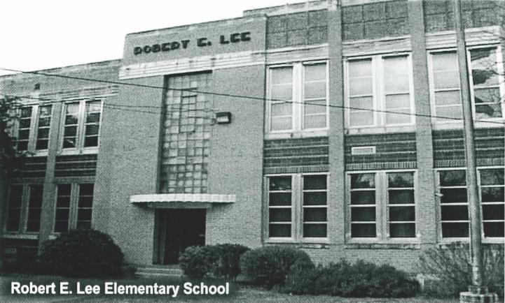
There were no public schools in the neighborhood until Robert E. Lee Elementary School was built in 1939. Prior to its construction, elementary students attended Baker School at 3908 Avenue B. University Junior High School was located at Martin Luther Ling (19th Street) and San Jacinto. Austin High School as located at 1202 Rio Grande, now the Austin Community College main campus.
Lutheran Concordia College of Texas was established in 1926 on 20 acres facing East Avenue between 32nd Street and the newly named Concordia Avenue. The land was purchased from the Hancock Estate for $19,000. Mrs. Hancock volunteered to donate one of the lots for Concordia Avenue, which became the city limits. The description of the property as it looked in 1926 is given in the 1977 history, Concordia of Texas - From the Beginning: " . . . our first college campus was in the fullest sense, on the outer limits of the city. Generally speaking, we had city conveniences . . . but no paved streets. Nature compensated us for the few inconveniences . . . Across East Avenue at 34th Street was a square block of veritable 'bird's paradise.'"
On June 27, 1926 the cornerstone for the first building was laid. It was named Kilian Hall in honor of Rev. John Kilian, pioneer minister of the Missouri Synod Lutheran Church. He had led 500 Wends to settle in Texas.
In 1926, the Cashway Bakery and Grocery was located in the red brick building still standing at 40th and Duval. By 1935, several businesses had been established on 43rd Street just west of Duval, including the Checker Front grocery store, a butcher shop, a barbershop and a beauty salon. A service station existed at 4300 Duval and a garage for automotive repair was at 410 East 45th Street. By 1945, a cleaner, a variety store, and a shoe repair shop had joined the cluster of businesses near 43rd and Duval.
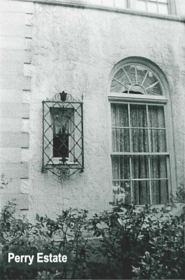
Two men who had a major impact on the development of Austin lived in the neighborhood during a portion of the 1920-1945 era. Edgar Perry, Sr. built his mansion on the site of the former quarry and gravel pit at 41st and Red River Streets. Perry used the fortune he earned as a cotton broker to build the Commodore Perry Hotel and the Perry-Brooks Building in addition to being the initial developer of Highland Park West and Highland Park neighborhoods.
Tom Miller lived on Park Boulevard and was mayor of Austin from 1933 to 1949 and again from 1955 to 1961. He was instrumental in obtaining federal funds for many projects that provided for numerous Austinites during the Great Depression.
Another resident of note was Morris Williams, who wrote about golf for The Austin American Statesman. He and his family lived at 517 East 40th Street. The municipal golf course adjacent to Mueller Airport was named for him and for his son who was killed in a World War II plane crash.
World War II and its attendant system of rationing caused Victory Gardens to sprout throughout the neighborhood. The families of servicemen stationed at Del Valle Army Airbase (later named Bergstrom in honor of the First Austinite killed in the war) rented houses or rooms in the neighborhood. University students lived in the many garage apartments in the area.
Post World War II to the Present
In the wake of the expansion of the Texas Capital Complex to the north in the 1950s, a number of homes were purchased and moved to Keasbey Boulevard, south of 45th Street, to the west of Red River. Also moved from the capital neighborhood was the parsonage of the Swedish Central Methodist Church, no located at 700 Carolyn in the Harper Addition.
No single development better signifies the change in the locality than the coming of Hancock Shopping Center. It was Austin's first shopping mall, built in 1963, on the site of the back-nine holes of Hancock Golf Course. A feature in the Austin American-Statesman, "Life and Arts" section, March 9, 1997, author Han Stuever caught the 35-year significance of the facility in this way: "What was right about Hancock Center was wrong for the mall boom. Hancock was one-third the size of present-day suburban malls and it did not have a roof. Highland Mall came in 1970 and the flock followed. It was the right neighborhood at the wrong time." With the coming of the newest and one of the largest H.E.B. Grocery Stores in 1997, the center had clearly been re-established as a focal point for the community.
It was the proposed sale by the city of the original nine holes of the golf course that led to the creation of the Hancock Neighborhood Association in the summer of 1980. As H.N.A. Historian Elise Plumb Kidd wrote in the Hancock Neighborhood Association Newsletter in September 1996, "Residents and golfers city-wide arose in support of continuing the course, not only for the sport itself, but also to ensure that this inner city treasure would continue as a beautiful greenbelt. H.N.A. flourished for many years with frequent meetings and excellent programs. After years of inactivity, it was revived in 1995 and efforts to rebuild it are ongoing." The first president of H.N.A. was Charles Harker, followed by Jim Beauchamps, Don Weston, Bill Bevier, Russell Hur, and Bill King. Richard Thompson, the current President was elected in 1995. The H.N.A. continues to provide a forum for the sharing of information and of community concerns. In 1998 it also sponsored the first Pet Parade.
In addition to the H.N.A., there is a Hancock Recreation Center Advisory Board, which serves an auxiliary function, including sponsorship of the Hancock Holiday Candle Trail - now a seventeen year tradition.
The Hancock Recreation Center serves more than 15,000 people each year. Its programs include adult enrichment classes and support groups, dancing and fitness. Among the youth camps and classes is the Tiny Tots day care, which began in 1963. An After School Fun Club meets the needs of K-6th grade children from Robert E. Lee and Maplewood schools. Supervisor Kate Tanguis reports that the Center is the site of one or two weddings, receptions, or parties each weekend throughout the year.
It is the increase in traffic, to be generated by the future development of the Mueller Airport site to the east and by the proposed Cencor Triangle development to the west which continues to define issues addressed by The Association. The continuing challenge for those who live and work in the area is to preserve it as an urbane oasis for present and future generations.
Hancock Neighborhood Architecture
By Blake Alexander
To the casual observer the Hancock Neighborhood is a collection of comfortable middle class residences situated conveniently near a large university though not, thus far, threatened by the urban sprawl which that proximity often entails. This impression is only partly correct. There is, in fact, a rich variety of housing, commercial and residential architecture within the bounds of the neighborhood. The residential architecture ranges from simple bungalows and modest cottages to some of Austin's grandest mansions. In addition, there are two churches, a small university, two schools, a golf course, and a shopping center.
Beginning at Duval and 32nd Street and going north, one is impressed by two blocks lined with handsome residences dating from the early twentieth century. Hugo F. Kuehne, Austin's leading architect of that day, designed many of these.
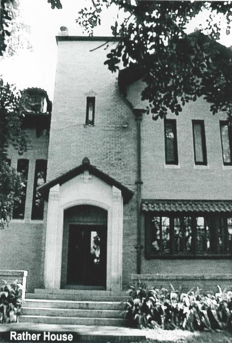
Although technically not in the Hancock neighborhood, as it is at the southeast corner of the intersection of Duval and 32nd Streets, the T. C. Rather house, now on the campus of The Episcopal Seminary of The Southwest, forms the introduction to the fine homes which stretch for blocks north on Duval and east on 32nd Street. The Rather house is important as an example of architecture unique in Austin for the sophistication of its design and as the work of the prominent Eastern architectural firm of Brigham and Coveney of Boston.
The house was built in 1911 for T. C. Rather, a successful businessman from Gonzales, Texas. The house is situated on a commanding rise above Duval Street and is dominated by a tower entrance element which was originally crowned by an elegant baroque cupola that could be seen from great distances as it rose above the surrounding grove of fine live oaks. Unfortunately, the cupola was removed a few years ago, at great loss to the aesthetic integrity of the house. The architectural style of the house is a restrained rendering of Spanish Renaissance Revival, reflecting a desire to relate to a cultural heritage of Texas. This echoes a similar expression in the architecture of two slightly earlier buildings near by, the Old Main Library (now Battle Hall) on The University of Texas campus and the University Methodist Church. After the death of the last member of the Rather family, the large property passed into the hands of The Episcopal Seminary of The Southwest.
Across from the Rather House, on the north east corner of Duval and 32nd Street stands the home of the architect, Hugo F. Kuehne. This imposing pink stucco mansion with its red tile roof and baroque ornamentation around the entrance and windows is in the Spanish baroque style although quite different in character from the Rather house. Kuehne's skill in designing fine homes in various styles popular in this period is displayed in a number of residences north along Duval and east on 32nd Street.
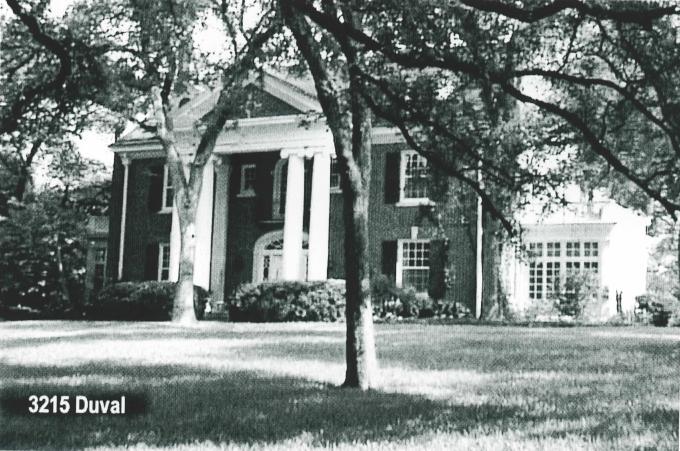
The Ben Barker residence at 3215 Duval is perhaps Hugo Kuehne's most successful residential design. It is a two-story red brick mansion with a classically proportioned central portico of four ionic columns, the finest example of Georgian Revival in Austin. The house was built in 1922 for Ben Barker, a prominent Austin businessman. Lewis Hanks, the grandson of Lewis Hancock, and his family later occupied the house.
Across Duval from the Barker residence is the Greek Revival home built for Fred Morse Sr. This is another classically inspired design; in this case it is in the Greek Revival style and was influenced by the ante-bellum architecture of Austin's first architect-builder, Abner Cook. The well-scaled Doric columns and strong Greek entablature are replicas of the columns from one of Abner Cook's fine pre-Civil War mansions.
Another excellent example of Hugo Kuehne's skill in handling the Georgian Revival is the house at 720 East 32nd Street that he designed for Dr. and Mrs. Robert Cox in 1927. Dr. Cox was a member of the Finance Department of The University of Texas, and was one of a number of faculty who chose to build homes in the Hancock neighborhood. The house is a symmetrical two story, five bay facade with a dormer gable roof. An elegant pediment sets off the entrance and a one story portico is supported by fluted Tuscany columns. The house displays Kuehne's usual refinement in details and carvings by Peter Mansbendel.
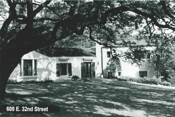
Also built for a university faculty member is the home at 600 East 32nd Street built for Dr. Milton B. Porter shortly after 1930. In this case the design is a picturesque Spanish Colonial rendered in white stucco on a multi-level composition which fits admirably into the gentle slope of the site, the whole framed by a magnificent live oak. The red tile roof and restrained detail of a Spanish character give the design a special appeal.
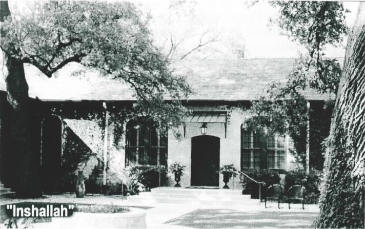
Farther north, at 692 East 43rd St., there is a particularly charming enclave of houses facing on a cul-de-sac which encircles an arm of Waller Creek and focuses on what is perhaps the eldest and grandest live oak in Austin. The principal feature of this group is the house called "Inshallah." President Sam Houston originally granted the land to Angelina Smith in December 1841. However, she did not build on it due, very likely, to the threat of Indian raids, which were not uncommon in this vicinity.
The first home was built by Joseph Lucksinger who had acquired the land in May 1872. He built a one story rectangular stone farmhouse. It was this house which Lindley Miller Keasbey and his wife, Cornelia Simrall Keasbey bought in May 1907. Lindley was a well-known professor of political science at The University of Texas, and Cornelia was active in musical and literary organizations in Austin. The Keasbeys added wings on either side of the original stone house, and the front remains very much as they left it, while there are later additions at the back. Cornelia was inspired by a richly illustrated edition of The Arabian Nights, and utilized the plates to show her builder, L. M. Ainsworth, features she wanted incorporated into the house. The Keasbeys named the house "Inshallah" an Arabic term for "God willing."
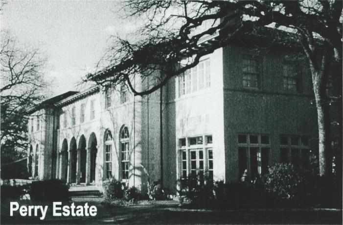
The establishment of the Austin Country Club in 1899 attracted a number of well-to-do families to this area who built fine homes in what was considered to be a rural setting. One of the founders of the Austin Country Club, Edgar Perry bought a large plot of land immediately north of the club at the site of an old stone quarry. In 1928, Mr. and Mrs. Perry built a magnificent Italian Renaissance villa. Taking advantage of the terrain they created an impressive formal terraced garden on the site of the quarry and placed the villa on an oak studded rise overlooking the garden and the Country Club. The result is still one of the finest estates in Austin. The architect was Henry Bowers Thomson of Dallas, a leading residential designer whose work in the 1920's graced Highland Park and Swiss Avenue in Dallas and Old Enfield in Austin. The house is a large symmetrical block with an arcade loggia recessed into the south front. The north entrance is centered in a projecting bay with a Palladian triple arched entry porch. The mansion is elegantly detailed with fine ironwork on doors, stairs, and balconies, balefully crafted wood paneling in the library and dining room. and marble and other stones in mantles and floors. The wrought iron is especially fine and is seen in balconies and fixtures both inside and out.
Facilities on the Perry estate have been used by a succession of schools in recent decades, Currently the Sri Atmananda Memorial School ls holding classes there.
After Perry built his elegant mansion next to the Austin Country Club, other wealthy Austinites were attracted to the Hancock neighborhood, and the fine homes on Duval and in what was named the Beau Site subdivision reflected this trend. Dr. J. R. Bailey developed Beau Site subdivision located on the south side of the Country Club around 1910. His original idea was to create an upscale neighborhood of large estates that would be in close proximity to the Country Club. The present Greenway St. (originally named Green Way) was the connecting passage from Beau Site to the Club. Dr. Bailey built his own home at 3504 Hampton Road in a modified Colonial Revival style, a large two story red brick house with a columnar porch suggestive of Mount Vernon. The idea of large fine estates attracted Julia Scarbrough Fisher. She and her husband Walter Fisher bought a generous plot across Hampton Road from Dr. Bailey. It has been said that Mrs. Fisher was not pleased when, after a time, the large lots did not sell, Dr. Bailey divided them into smaller units and more modest homes were built. The Fisher house at 3509 Hampton Road was built in 1934. Mrs. Fisher was the daughter of E. M. Scarbrough, the founder of Austin's major department store. After extensive travels in France, she was charmed by French art and architecture. She dreamed of building a French country house in Austin, and while attending the Chicago World's Fair in 1933, she sought the advice or authorities at The Art Institute of Chicago. They gave her the name of the architect, Harry Howe Bentley, or Ravinra, Illinois, and he produced the plans for the house that Mrs. Fisher named "Le Manoir."
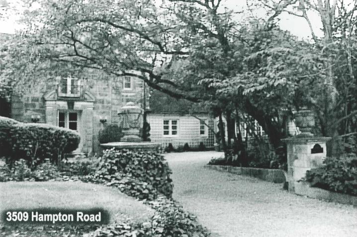
The Fisher house is an excellent example of the French Renaissance style as interpreted by the eclectic architects of the early twentieth century. The house is approached through a gate formed by a pair of urn topped stone piers leading into a gravel forecourt, characteristic of French manor houses. The entrance is centered in a projecting gabled bay with corners enhanced by quoins. The door is framed by a classic broken arcuated pediment, again a feature or French Renaissance design. The interior is dominated by a large salon with beamed ceiling, French doors, and a Louis XV mantel.
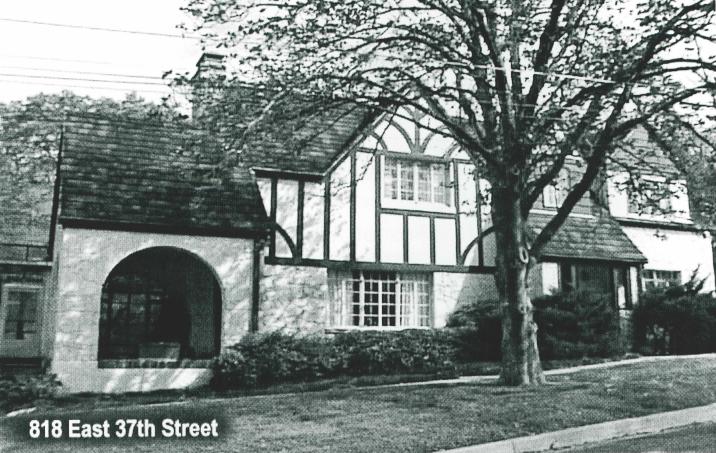
Among the eclectic styles popular in the 1920s and 1930s was the Tudor Revival. As the name implies, it is a romantic revival based on sixteenth century English architecture and is characterized by picturesque asymmetrical composition capped with steep gable roofs and mock half-timber detailing. Excellent examples are to be seen at 815 and 818 East 37th St., 3500 Greenway, and 801 and 803 Park Blvd.
Building on 38th Street east of Waller Creek was opened up with the construction in 1941 on the Percy V, Pennybacker, Jr. house in the 800 block, although the remainder of the block would
be vacant until after World War II. The Pennybacker House was built for the noted highway bridge engineer and was designed by the architects Harold and Wolfe Jessen in what might be labeled a Texas Vernacular style, characterized by long horizontal lines of the so-called Ranch Style, built of the local Austin limestone, and with traditional touches such as multipaned windows and topped by low pitched gable roofs. The Jessens were also the architects of the home of their brother, Werner Jessen at 836 East 37th Street, a house which was built after World War II, and which displays a more contemporary design.
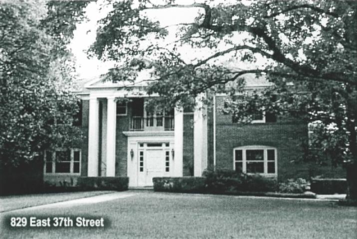
Two fine homes in the Georgian Revival style were added to the Beau Site addition after World War II. The home built for Mrs. Bryant F. Collins at 829 East 37th St. is a two-story red brick Georgian design with a central portico of paired box columns in a Palladian mode. The most recent addition to the neighborhood is the impressive residence of Mr. and Mrs. David Anderson at 3501 Hampton Road. The two story rose brick residence is a thoughtfully executed Georgian design that boasts an accurately scaled portico of six ionic columns. The attention to detail is reflected in the Flemish bond pattern of the brick veneer.
The Lutheran Church, Missouri Synod, established Concordia University in 1925 as a high school for boys. The school was sponsored by the Wends community in Texas in furtherance of Wends culture and religious heritage. The church purchased 20 acres at the northern city limits, two miles from the Capitol. The cornerstone for the fist building, Kilian Hall, was laid in 1926, and the first classes were held that year. The architects for the first
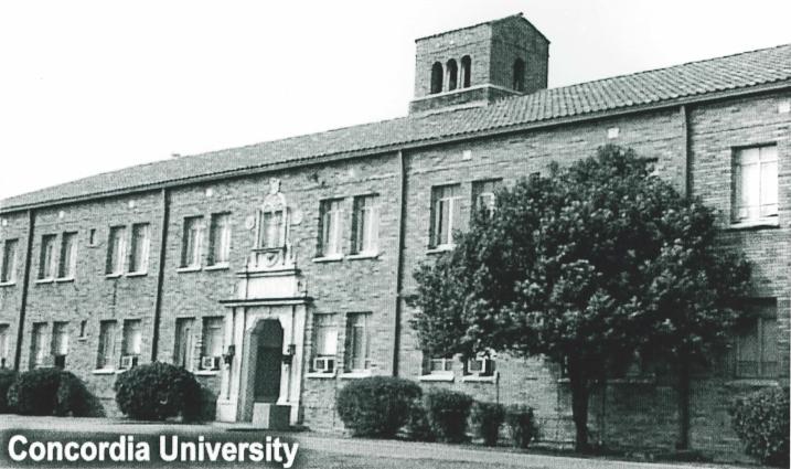
building were Harvey P. Smith and Arthur Fehr, who chose a modified Mediterranean Romanesque style for the campus. This has been retained and as a result the campus presents a very pleasing architectural unity. Kilian Hall was built of a warm red-orange brick, Spanish tile roof, and a fine set of doors by the Swiss carver, Peter Mansbendel. After progressing to a junior college, Concordia became Concordia University in 1995.
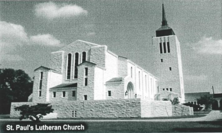
In 1958, St. Paul's Lutheran Church built a handsome new sanctuary and school at 3501 Red River on a site which adjoins the campus of Concordia University. The design is based on a traditional Latin cross plan with a prominent central tower at the west facade and main entrance. Tall round arched windows light the high central nave, and they and the round arched entrance reflect the Romanesque influence to be found on exterior and interior detail.
The Robert E. Lee Elementary School, located on the 3800 block of Hampton Road was built in 1939 by the Austin independent School District and funded by the Federal Works Progress Administration. The architects, Giesecke and Harris with Roy L. Thomas as associate architect, achieved a design which successfully blends with the neighborhood in scale and character. The building is long and low without any overwhelming monumentality associated with earlier school designs. The buff brick with dark brown tile insets adds attractive detail and the glass block panels and entrance canopies give away the 1930s Art Deco style of the building. The recent 1998 addition of a library building for the school is a most successful complementary design by the architects Coffee, Crier, and Schenck.
By 1964 the Austin Country Club had moved to a site south of Town lake, and the eastern half of the golf course consisting of nine holes east of Red River and north of 41st Street, was sold to a developer who built the Hancock Center, one of Austin's first shopping centers. Unlike the later vast air conditioned shopping malls, Hancock Center was built around a beautifully landscaped central court replete with trees, planters, and colorful tiled fountains. Colonnaded walkways provided sheltered access from store to store no matter what the weather. The design received national acclaim for its success as a unique public amenity. The design of the central court and its landscaping was the work of the noted landscape architect, Lawrence Halprin.
A Brief History of Hancock Golf Course: The First Hundred Years
By John W. Ramzy, Ph.D.
Lewis Hancock, our neighborhood Founding father, visionary, and a mayor of Austin, organized a meeting of close friends at the Driskill Hotel in 1899 for the purposes of organizing a golf club. Hancock had become interested in golf through his travels including trips to Scotland. He was elected President of the club unanimously by this group of citizens that included Professor David Houston, Will Bell, Drs. Clever, Jack Phillips, and T. W. Gregory. (1) This organizational committee filed Articles of Incorporation on January 10, 1900 with Messieurs Hancock, Houston, Gregory, David Harrell, and R. H. Connerly as the five original directors. Golf has been played longer at this location than anywhere else in Texas.
The members sought out to find acceptable locations for the nine-hole gall club Several locations were considered, and the most popular among the directors was the strip of land fronting on Groome Street, today known as Duval. This land was leased to the club. The small nine-hole course was constructed with sand greens. Lewis Hancock has been known to have personally scraped fairways with farm implements. This land was later abandoned for land east of Waller Creek, and later the land west of the creek as we know Hancock Golf Course today.
The first central gathering point for the newly formed golf club was a large mesquite tree on the hill overlooking Waller Creek. This tree as stall very visible today, and can be found along the current boundary along Peck Avenue. Shortly thereafter, in 1900, a small shack was built for $100 to serve as the clubhouse. A fire, a frequent occurrence at the golf clubhouses, later damaged it.
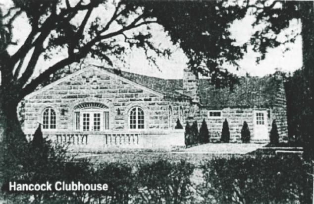
In June of 1901 the members celebrated the dedication of the first real clubhouse which was a two-room, wood-framed building which today can be found as a remodeled residence at 512 E. 39th Street. In 1908 a new, much larger, two-story, red clubhouse was built at the current location of the Hancock Recreation Center and Golf Shop.
In 1914, after fire damaged the building, it was reconstructed and enlarged to accommodate the growing membership. At this time there were approximately 300 members. This stucco clubhouse was painted white and green and again destroyed by fire on March 14, 1934 after a Saturday night dance, and at a time when the insurance coverage of the clubhouse was found to be well under the replacement value of the improvements. Yet the resourceful members again remodeled the structure that same year. At the same time, the University of Texas was tearing down Old Main and the membership arranged for use of some of the materials being torn down. The membership elected to acquire the brick and stone and reuse the materials for the new clubhouse, which was adorned with stucco as well.
In 1963 fire struck again and damaged a portion of the by-then city-owned clubhouse. At this time under city ownership, the building was repaired with a major alteration transforming the kitchen into a classroom.
Julia Pease, daughter of Governor Pease, was one of Austin's first lady golfers. Proper attire for lady golfers during the era was long skirt.
Betsy Rawls played at Hancock and Hilda Urbantke was a top amateur player out of Hancock. Other players at Hancock included Martha Westmorland, Patty Berg, and Louise Suggs. Hancock attracted top players, many coming for exhibitions
Notable members of the early Country Club days at Hancock included T. W. Gregory who was, along with being an original member of the club, served as Attorney General of the United States under President Woodrow Wilson; Dr. David F. Houston who was former Secretary of Agriculture, Secretary of the Treasury, and later President of the University of Texas; Lyndon B. Johnson who served as U.S. Representative, U. S. Senator, U. S. Vice-President, and U.S. President; John Connally who served as Governor of Texas, as Secretary of the Navy, and as Secretary of the Treasury; and J. J. Pickle as U.S. Representative.
Local talent playing out of Hancock included amateurs Tom Miller Jr., Jimmy Connolly, Buck Luce, and Morris Williams, Jr.
A famous gambler paid two visits to the club. He was Titanic Thompson, of whom there are books and articles written. He was a hustler and known for his feats on and off the golf course. Once he bet the members he could throw a peanut over the clubhouse, and did!
Another time in the late 1930s a financial disaster struck. The Texas Rangers raided the club removing three illegal slot machines, and taking sledgehammers to them in the club parking lot.
The first documented competitive golf contest was February 21, 1900, with Mr. Walter Bremond winning the handicap tournament and scoring a net 73 score for two rounds over the layout. Mr. Hancock presented the winning medal to Mr. Bremond. (2)
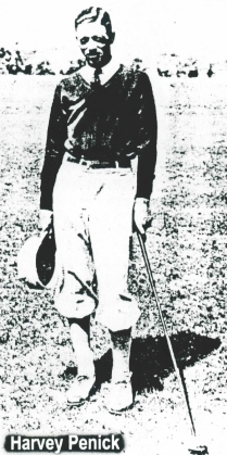
The first club professorial was Bull MacKenzie, followed by George Dow, Carl Baker, Jim Smith, and 18-year-old former caddie Harvey Penick who began has professorial career at Hancock/ Austin Golf Club in 1923. The club directors held the vacant position open for Harvey for one month so he could finish his final year of high school.
As the club grew, the membership elected to accommodate an expansion to an 18-hole golf club. Edgar H Perry, the club's second president, led efforts to acquire the 40-acre Ernst Farm. This land was acquired on February 18, 1913 (3) and is the current location of the Hancock Shopping Center. The purchase price of the land was about $400 per acre.
The course architect according to golf course researcher Frances G Trimble, was John Bredemus, the same architect who designed Colonial Country Club in Fort Worth. The 18-hole course had a par 36 front and par 36 back nine. The back nine had very few trees with fairways shaped among mounds, high rough, and bunkers similar to the Scottish style links courses. There was no driving range at Hancock.
The 12th holes was a par three with players teeing off from just east of Red River Street, attempting to negotiate the flight of the ball over the street, onto the 12th green which today is located in the depression at the northeast corner of the existing course.
Members received much criticism for golf balls flying over the street and eventually had to shorten the 150 yard hole to about 70 yards and eliminate the over-the-avenue flight of golf balls.
In 1946, the Austin Country Club was interested in selling the entire property consisting of 93 acres and relocating outside the city limits. Mayor Tom Miller was in support of the city purchasing the property to add to the recreational properties for the citizens of Austin. A large public hearing was hold in September of 1946 and mixed response wars hoard from the citizens regarding support for the city purchase. After many formalities, the city ultimately accepted the country club's below-market value offer to sell the land to the city for $175,000. The transaction closed in December of 1946, with the final deed recorded January 3, 1947.
The City of Austin became the owner of Hancock Golf Course in its entirety. The Country Club remained in operation under city ownership for three years while the Riverside location was being completed for relocation. In January of 1951, the Country Club officially gave the city operation of the golf club grounds and clubhouse.
Dedication of the property as a park was not so certain. Already in the minds of Austin's leading citizens was the intention to dispose of the Hancock east 40 acres to finance other recreational developments for the City of Austin. A motion for the City Council to dedicate the entire property as a park failed 3-2. A motion to dedicate the 50 acres lying west of Red River passed unanimously. This action left the back nine vulnerable to disposition by the city leaders. Almost immediately a movement developed to sell the back nine property.
In September 1954, the city had interest from private parties to sell the back nine property. Several offers were received. On December 8, 1959, the city agreed to sell the Hancock East 40 to Homart Development for $800,000 and a deed was filed for the sale on December 8, 1959. (4)
Shortly alter the sale, litigation was filed by interested taxpayers. The suit ultimately went to trial with Judge Herman Jones presiding. The decision was that the back nine had been dedicated as a park, and the city council overstepped their jurisdiction by selling the land. He ruled that since the land had been used consistently as a public park, the sale was subject to a public vote. Later a referendum was held on February 10, 1962 for the citizens to decide the fate of the back nine. Many citizens favored the sale since the city had proposed a five-year capital improvement program to parks and playgrounds on city recreational properties. Funding from the $800,000 proposed sale would be used to fund these improvements.
The election was a hotly contested one with major campaigning by both sides. No title insurance had been issued to Homart, so the sale was not complete. Among those city leaders who were pro-sale included Edgar Perry as Mayor Pro-Tem, Mayor Lester Palmer, Hub Bechtol, Ed St. John, Louis Shanks, and Ben White, the latter two of whom were Councilmen at the time. The voters approved the sale and construction on the Hancock Center began in 1964. (5)
In 1980, due to operating deficits at the city owned golf course, the Parks and Recreation Department proposed closing the golf operation at Hancock. The annual deficit of $30,000 gave rise to the notion that the city would close the golf course and turn the open space into softball, soccer fields, and open space. An opposition charge by the newly formed Hancock Neighborhood Association kept the course operation alive. Hyde Park and Red River neighborhood associations joined in the opposition. The City of Austin today operates the nine hole public course and the clubhouse is used primarily as a recreation center. Steve Darby is the club professional. Numerous groups meet regularly at the recreation center. A major focus is children's programs such as introduction to golf workshops and a number of ongoing sports activities. No apparent attempt is underway to close the golf course and for that we are grateful.
Notes:
(1) Austin Daily Statesman, November 14, 1899, with compliments of Ham-Mer Consulting Engineers, Inc. as noted in The Women's Texas Golf Association
53rd Annual Tournament booklet of the Country Club of Austin, 1974, p.43.
(2) Austin Daily Statesman, February 22, 1900 with compliments of Stripling Blake Lumber Co., Inc. ibid., p.47.
(3) Elane Taylor Brown, "Hancock Recreation Center, an Historic Preservation Documentation AMC 389," for Dr. Wayne Bell research paper, University of Texas, May 10, 1984.
(4) Ibid.
(5) Sam Griswold, "Hancock East 40 - From Country Club to Shopping Mall," The Maplewood Messenger, A Free Community Newspaper, March, 1982.
OUT OF THE ORDINARY: THE HISTORY OF HANCOCK CENTER
By Jalaane Levi-Garza and Louis Pauls
At the turn of the century, former Austin Mayor Lewis Hancock took a jaunt to Europe and discovered the game of golf. He decided to import the game to Austin and consequently purchased 90 acres on the outskirts of town, just north of his estate, Sunnyridge. The City rezoned the back nine or East 40 as commercial in 1959. Safeway Food Stores made the first offer of $300,000 for the land, however it was declined. In the same year, the City held an open bid hearing in which Homart, the development arm of Sears Roebuck and Company offered $800,000 and unveiled plans for a $8 million regional shopping center with 28 stores.
The sale was approved but a lawsuit was filed by local residents led by Robert Zabel who voiced many concerns, not the least of which was the sale of Public Park land without a referendum. The suit held up development for several years until a judge ordered that action on the lawsuit be taken and the issue was brought before the citizens of Austin.
Austinites voted 5-to-1 in favor of the sale. An appeal was denied and within seven months Sears had opened as the first store in Hancock Center. At the same time, Sears closed its Congress Avenue store, which marked the beginning of a decline in downtown retail. Local protest continued during the construction of the rest of the mall. A compromise victory was reached when 250 trees were planted and fountains installed where shoppers could move about in a veritable garden of flowers, shrubs and trees indigenous to the Southwest.
It was a bright and sunny day in October 1963 when Crowdus Baker, the president of Sears, was present at the ribbon cutting ceremony. Austin Mayor Lester Palmer, Miss Texas and local radio celebrity Cactus Pryor joined him. One year later, the entire center opened with 34 stores. As the brochure read, "Hancock Center is a place where convenience makes shopping an unforgettable
pleasure in an atmosphere of unsurpassed beauty that is truly out of the ordinary."
At the time of opening, Hancock Center was the state of the art in retail in America and a sure sign that Austin was growing up as a city. Austin now had its first major mall, the first Dillard's store in Texas and a Sears more than double the size of its original downtown store. Shoppers came from all over Central Texas.
Hancock Center anniversary celebrations became cultural events and were delivered in style. In 1971, the Hancock-Goes-Hawaiian celebration lasted a week and 10,000 orchids, flown in from Hawaii, were given away to customers. Another year it was Viva La Fiesta! held in September as a celebration of Mexican Independence Day. This was the time of console color televisions, stereo component systems that included three speed turntables, and washers with Roto Swirl Agitators. The well-dressed man shopped at Merritt, Schaeffer, and Brown and women who wanted to be fashionable shopped at Snyder Chenards, Leon's, and Merle Norman Cosmetics.
Of course, men still wore pajamas, flared double knit slacks and women's fall coordinates were advertised as 100% polyester. It was a time when Hancock Center stores used words such as "groovy" in the ads and one store attracted teenager customers by saying that it was "a place where a young man can choose a color coordinated wardrobe that's turned on and tuned in from the top of his turtleneck on down".
One feature of Hancock Center that seems unique today was a Town Hall facility that was used as a meeting place and showroom. It had a capacity of 350 and during the 1960s was hosting 30,000 people a year for events which included The African Violet Show, The UT Law School Wives Style Show, and various exhibits from the Laguna Gloria Art Collection. Ten years after it opened in 1964, Town Hall was still one of Austin's favorite places to gather. In August 1973, an ad in the Austin American-Statesman read, "The fall season will again find Town Hall at Hancock Center a busy community facility with Back to School parties, fashion shows, and yes! classroom sessions too!"
The decline of Hancock Center could be traced to the opening of the fully-enclosed Highland Mall in 1970. However when Homart sold Hancock Center an 1977, it was still 95% occupied. The buyer, Kingsmere Corporation, was based on the East Coast and represented a Dutch pension fund. Kingsmere sold out an 1990 the same year Dillard's closed at Hancock Center. By that time, the Center seemed to have become the ghost of malls past, its former glow a passing memory an the minds of early baby boomers.
The Center was sold again an the 1990s. With developers giving it one more go, they announced plans to invest $11 million in remodeling which included a roof to cover the entire center. More than once, this proposal was called the sure thing to revitalize Hancock Center. Yet, tenant turnover continued. The southeast building was demolished and the fountains were torn down. One developer even said "That mall has what you call functional obsolescence."
Pacific Retail Trust acquired the mall in 1996 and unveiled H.E.B.'s plans to construct a new grocery store with 94,000 square feet, almost three times the size of the original store opened in 1964. H.E.B., a perennial Hancock Center success story, now has new space that glorifies the mundane in everyday life. From the international flavor of prepared foods to the pasta specials freshly prepared by a resident chef in the Cucina Italia, shopping has been transformed from a chore to an enjoyable experience.
Everything old is new again at Hancock Center. The addition of Old Navy, Petco, Hollywood Video, Boot Town, General Nutrition Center, new restaurants and plans for more retail including a new music store have helped create a commercial renaissance in a residential neighborhood, which in itself has been reborn in recent years. Hancock Center may no longer compete with Barton Creek Mall, Lakeline Mall or even the aging Highland Mall, but it has a life all its own. One with a steady pulse and regular heart beat. Just ask the guys who run Hancock Barber Shop, John Cornejo, Landis Powell, Cliff Smith and Joe Simcik. They have served the neighborhood for more than thirty years, quietly going about their business. They have in their own way helped to create a stabilizing force in Hancock Center. "It had its days," Cornejo recently said of the mall, "but we are still here." They have seen all the peaks and valleys and now they bear witness to the most recent revival of Hancock Center as it carves cut a new piece of history and reputation as a survivor.
Those who grew up with Hancock Center in the 1960s and 1970s have many fond memories of a first pair of shoes, a new lawnmower, a daughter's wedding dress or a diamond anniversary ring. Now they can combine that storied past with an opportunity to provide their children with a chance to write a new chapter for the 21st Century.
Additional information provided by The Austin-American Statesman and The Austin History Center.
Beau Site: A Case Study
By John G. Bordie
The area presently designated as Beau Site in City records encompasses the residential group between Harris Boulevard to the south, 38th Street to the north, Red River Ave. to the east and Waller Creek to the west. The area has a complex history that is marked by land speculation, loan defaults, re-capitalization and shrewd development planning. Some of the speculators and developers were individuals of honor and character, others were quite the opposite.
Beau Site's origins can be traced to the original state land Patent 163 V.2. State of Texas to Masillon Farley on March 1, 1849 that granted him Lots 6 & 9 of block C on the City of Austin plat; Lots 7 & 8 were granted to Farley a few days later. Lots 20, 21, 22, & 29 had been granted to Farley in late 1848 and were sold to Jos. C. Swisher in January, 1849.
Swisher purchased lots 6 & 9 in April 1849 for $130. All of these lots were sold by Swisher to Francis Dietrich in April, 1850 for $1500. The increase in value by a factor of 11 within one year testifies to the land boom then underway within the state subsequent to the conclusion of the war with Mexico. After the death of Dietrich, the lots were passed to his wife Sarah E. Dietrich as community property. She married J.W. Whipple in 1863 and the lots, valued at $8000 were transferred to both their names. These lots were posted as surety for a $13,775 dollar loan to William A. Blackburn who was trustee for Anna J. Robards. There were complications and loan default sales during the next six years. A quit claim to Whipple for lots 6, 9, 29 was filed in June 1875 by J.W. Hannig who had acquired a lien. Robards transferred the other property to Hannig in July 1875 (filed September 1879!). Sometime prior to June 1877, Whipple had sold 3/8ths of an acre from lot 6 to J.B. Rector. Whipple sold the acreage remaining of the original property to Rector in May 1889 for $5640. This property was sold in April 1890 to Johnson, Ross and Terrell for $6250 before the founding of the Austin Country Club which would be located at its north boundary.
Beau Site subdivision was developed by Dr. J.R. Bailey around 1910 Dr. Bailey was one of the two individuals who worked out the formula for Novocaine when World War I prevented access to the German product. Bailey and the other developers of Beau Site viewed the location as being ideal for an exclusive community possessed of substantial attractions for those with the desire for space, proximity to a socially prestigious venue, and a taste for discreet elegance. Lot sizes were, and still are, quite large. Several lots were substantially larger than one acre and a number were greater than two acres. It was intended that such lots were to be for the construction or estate-sized structures. Primarily located on 37th Street, Hampton Road, and Greenway, these lots reflected the space sizes of other estates in the adjacent community such as the 2.5-acre site on Fairfax Walk north of 32nd Street. The exclusive nature of Beau Sale was underscored by its apparent isolation from the remainder of the city. 38th Street and Harris Avenue both stopped at Waller Creek. No bridges crossed the creek at those locations until the late 1950s. Greenway was not opened to 38th Street until the mid 1970s. Access to Beau Site was limited to the east end of 37th Street at Red River and the south end of Hampton at Harris.
The cost of such large size lots would necessarily restrict the nature of development in the area but the developers established a series of deed restrictions and conditions incumbent on ownership for the future purchasers of the lots. This was intended to keep the area exclusively residential. As early as the 1920s, deed restrictions began to appear which reflected concern that non-residential commerce might be poised to invade. Deed restrictions forbidding such commerce became extremely common at that time. Many restrictions simply ban commercial business: "no commercial business" being a common phrase in many deeds. During the 1930s and 1940s such a direct statement seemed to be insufficient as more powerful, specific and inclusive restrictions began to be used: "no trade, manufacturing, or mercantile establishment: no commercial garage; no livery stable would be permitted and no animals may be kept." Reflecting a 1920s view of proper commerce "no liquor [is] to be manufactured or sold within the area."
This desire to maintain the area exclusively residential is found in those deed restrictions which state that land is sold for residential lots only, and that all "structures [are] to be single family units for residential purposes only." To maintain the up-scale values of the neighborhood there could be "no subdivisions of existing units, no building to be closer than 25 feet to front of lot; and all structures [are] to be constructed of brick, stone, or concrete." Surprisingly, given the goals of the developers, the framers of these restrictions were not very good at predicting future real estate Values because one of the common restrictions is that "no house [is] to cost less than $5000."
There were further urban planning views regarding the nature of residential construction in order to maintain the exclusive coherent appearance of the neighborhood "all residences must face the front of the lot, garages must be kept, cars must be garaged; no motorcycles or three wheeled vehicles, no trailers shall be permitted." Similar limitations were imposed to maintain the physical broad sweep of avenues and boulevards One exception to the view that the area was to be a network of such boulevards is Greenway. Inset into the curbing at the corner of 35th Street and Hampton Road is the blue and white tile street marker identifying Greenway as Green Way, the path to the golf course. There was also a public footpath from Hampton to 38th street east of 822 37th Street that was the shortcut to the golf course before Greenway was cut through to 38th Street.
A downside to these restrictions were those which emphasized race: during the 1920s and 1930s such restrictions excluded blacks; this was modified somewhat during the 1940s when the restrictions read "only Caucasians" to reside. The restrictions limited residence but not ownership by certain races.
To ensure that such restrictions would be observed many deeds state "It shall to be lawful for anyone in Beau Site to sue for damages in case of violation of these restrictions." Street names in the Beau Site area reflected the conventions of the times. 37th Street was originally Oakview Avenue and was renamed during the 1930s citywide renaming of east-west streets. Oakview then ended at Hampton Road. The segment between Hampton and Greenway is shown on city plats as a continuation of Hampton Road which, in turn, continues northward from its intersection with Greenway. The south end of Greenway, according to the 1932 Austin Mayoral proclamation, begins at the corner of 35th and Hampton and has its north terminus at 3700 Greenway. Perhaps for postal address clarity the plat names were modified to their present configuration during the 1940s.
Harris Avenue and Harris Park Avenue were named for Sidon J. Harris, a turn of the century developer in the area. Residents along those streets might reconsider the honor since Harris had many problems with his financiers. The last deed to mention him in the early 1900s states process could not be served as S. J. Harris had gone to Cochise County, Arizona Territory! Cochise County is the location of Tombstone and its famous cemetery.
Acknowledgements
Thanks to the following individuals and companies that madethis book possible with their generous contributions.
Becky Phillips and Bill Bednar
H.E.B. Grocery Stores
Express Automotive
Elise Plumb Kidd
Susan J. Pryor
Guy C. Baird
Laurence and Rosanne Becker
Jalaane and Daniel Garza
The Griffin School, Inc.
Bernice M. Johnson
David Justice
David and Joyce Orr
Thomas G. Palaima
Westelle and Oscar Paul
Emily Puckett-Notely
Phyllis B. Roberts
Rich Thompson
Philip Treisman
Ernie W. Tullis
© Copyright 1999, 2011 Hancock Neighborhood Association. All rights reserved.